Sunrise Highway (NY-27) Oakdale Merge Planning / Feasibility Study

As part of a Regional Design Services Agreement (RDSA), the project served to identify, evaluate, and document existing conditions and deficiencies and propose feasible conceptual alternatives to mitigate said deficiencies.

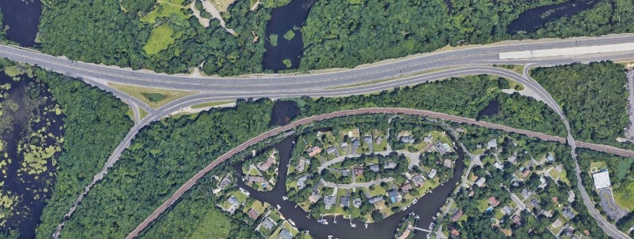
The project site experienced significant congestion and delays during peak travel periods, as motorists encountered recurring bottleneck in the eastbound and westbound approaches to Oakdale Merge.

The feasibility study described the highway facility and its role in the local and regional surface transportation network, defined existing operational issues and deficiencies, established the need for a capital construction project to reduce the issues, recommended and assessed various alternatives, and assessed the impacts of each proposed alternative.

The scope of work also included review of environmental impacts due to the site’s proximity to New York State of Department of Conservation (NYSDEC) wetlands and the Connetquot River State Park. The project required continuous coordination with the New York State Parks Department, NYSDEC, Suffolk County Department of Public Works (DPW), and the Town of Islip.

KC was responsible for developing detailed cost estimates for the alternatives identified in the feasibility study and performing HCS traffic analyses.


Shoreham Deep Water Port Project

KC was engaged to perform surveying and engineering services in support of a Governor’s Office initiative to provide a feasibility study for developing a proposed deep water port at the abandoned nuclear power plant site in Shoreham, Suffolk County, NY.

Survey tasks included setting horizontal and vertical control for a photogrammetric survey of the 125 +/- acre plant site area and bathymetric survey of the one-mile channel servicing the original power plant site. Additional tasks included providing primary control azimuth pairs to NYSDOT specs, ROW determination of bounds of Old County Road, topographic mapping of the 800 +/- surrounding project limits, and research/plotting of the LIPA and National Grid parcels defining the project limits and utility corridors serving the plant site.

KC is now involved in the feasibility study associated with the project. This study has been undertaken to determine if a deep-water port could reduce truck trips and traffic congestion on Long Island and Metro-New York roadways. Various components of a deep-water port have been factored into this feasibility study, namely site access requirements and improvements, linkages to existing transportation facilities, nautical configurations, operator interest, capital expenditures, maintenance costs, market forecasts, funding mechanisms, jurisdictional authority, permit requirements, potential environmental impacts, and construction effects.

Four feasible port planning scenario concepts have been formulated; a preferred concept has not been articulated as further analysis and the implementation of a public involvement program in a subsequent study phase would be needed to identify a preferred scenario concept.